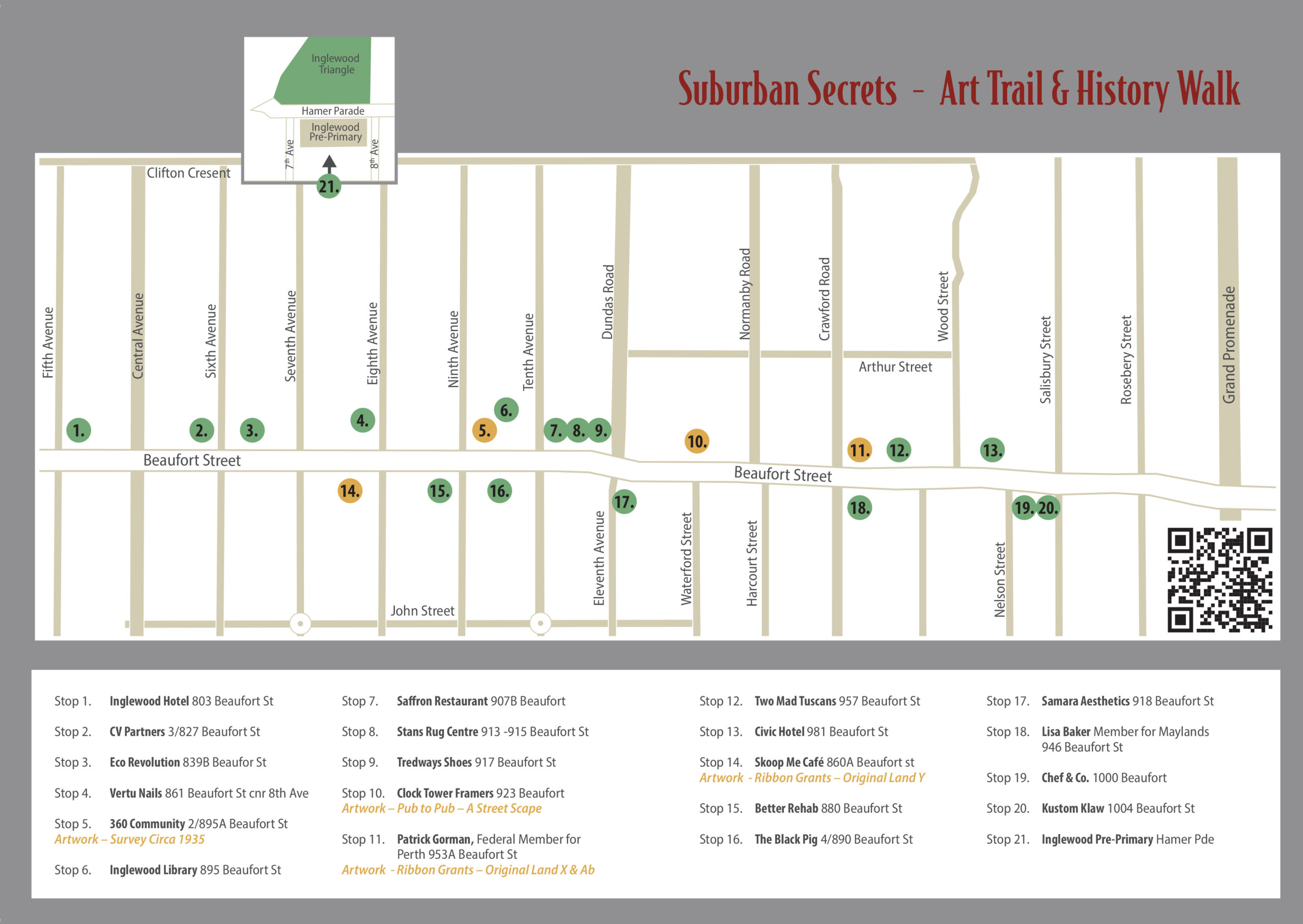
 Stop 1. Inglewood Hotel 803 Beaufort St
Inglewood hotel 1983, 1993 (with fence) 
 Images courtesy SLWA, Fox hunt
 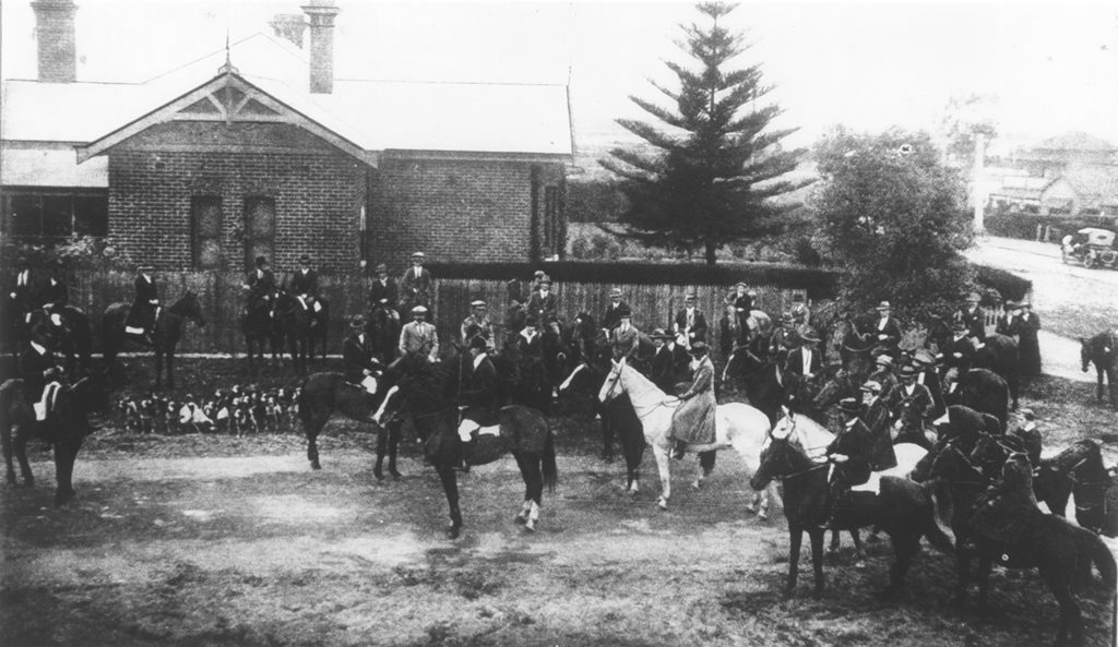 Image courtesy CoS History Collection
Opened 16 May 1936 Heritage listed Interwar Spanish Mission Style, with elements of Interwar Functionalist style. Designed by well known architects Parry and Marshall Walter Clifton, and built by E. Allwood. Alterations and additions in 1953, 1969-70 and 1992.
“Cream walls and a bright green roof. Upstairs sitting rooms have textures walls and elaborate molded ceilings. Hall and lounge downstairs had exposed brick walls and heavy jarrah ceiling beams. Bars have terrazzo paneling and Chrome fittings – refreshingly modern.”
At the time a caveat existed for no hotels in the Mt Lawley area because, as legend has it Lady Lawley allowed the suburb to be named after her on the condition that there be no pub in the area. Fox Hunters assembled at the Inglewood Hotel, preparing to head out towards bushlands in Bayswater, Dianella, and Yokine.
Stop 2. CV Partners 3/827 Beaufort St
Jan 1951 McGovern Butcher.  Image – Noel Reed.
This site has been continually occupied by a butcher shop to the present day.
Stop 3. Eco Revolution 839B Beaufort St
1930s Riley’s Hall on the right hand side, middle shop after the grocer.
1985 Open Markets Images courtesy CoS History Collection
Built for Mr Riley as a public hall. It was used for weddings, balls, a children’s fancy dress competition 1937 (250 children attended), voting, cricket award nights, football club, Inglewood Branch Children’s Protection Society Ball 1938 (450 people attended), a public meeting to build the Post Office (by Inglewood Progress Association), Red Cross Trainings 1939, sewing circles, works meetings 1941, a boxing night 1946, Home Nursing films by the Red Cross, Government speakers, politicians, National Fitness classes 1940, (prevention health during WW2) Keep fit displays, Bridge parties, Public Meeting 1948 State Government action in the eradication of the Argentine ant problem, The Nazi Party of WA rally 1930s and The Coolbaroo Club dances for Aboriginal people in 1955.
From 1960 – 1990s the building was used as a fruit and vegetable open market, then various delis until 2005 when Rembrandts, the first restaurant on the site opened.
Ref: Cos, Trove, SLWA, Dodge Perth
Stop 4. Vertu Nails 861 Beaufort St cnr 8th Ave
Horse Trough  Image courtesy CoS History Collection
“The horse trough at the cnr of 8th Ave & Beaufort St served only one useful purpose – it provided a popular bath for dogs, Inglewood hardware merchant B. Wright said yesterday. He had seen dogs bathing in the greenish water in summer, but had not seen a horse have a drink there for ten years…”
Newspaper article End of the Horse Age 20/7/1961
Stop 5. 360 Community 2/895A Beaufort St
Inglewood Library 1969  Image courtesy SLWA
Inglewood Autumn Centre 1990,  Inglewood Infant Health Centre,
  Demolished 1991 Images courtesy CoS History Collection
The Infant Health Centre opened 1941 and was on the cnr of 10th Ave. The library and Autumn Centre pictured opened in 1963, the library was enlarged in 1964 & 1968. The current buildings opened in 1993.
Artwork by Louise Wells RetroMaps from the State Records Office of Western Australia show the original surveys of Perth up to 100 years ago. The plans were used as part of the installation of the sewerage system. The maps show Inglewood as it was around the 1930s. Survey Circa 1935 slowly hand stitched on silk organza, outlines the streets, subdivisions, and blocks and has helped me understand the size of the land, the structure, the amount of land the golf course takes and the little amount of remaining natural bush that is Inglewood Triangle. The red lines show the original ribbon grant subdivisions. It has me question the layout. Why is there a kink in the road? Why do the block sizes change? The laneways disappear? Look how narrow some of the shops are.
Stop 6. Inglewood Library 895 Beaufort St
1954 Inglewood Motors,  1990 PIT Theatre
  Images courtesy SLWA.
The building on this site prior to the current library (1993) was a car yard, then grocery store, then PIT (Perth Independent Theater) and CYSS (Community Youth Support Scheme). Demolished Dec 1990.
Stop 7. Saffron Restaurant 907B Beaufort
1984 Ludwig ll von Bayern Bavarian Restaurant formerly Schnitzel Inn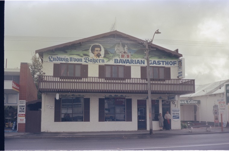
1994 Western Grill 
Images courtesy SLWA
Stop 8. Stans Rug Centre 913 -915 Beaufort St
1958 Looking towards Perth.
Image courtesy SLWA
1985 Looking towards Perth
1939 Civic Theatre
1994 Civic Clock Tower
Images courtesy CoS History Collection
The Piccadilly Picture Gardens built in 1926 by Thomas James Snooks (1890–1958) a local picture-show man and builder-developer from the 1910s to the 1940s. It was one of the first outdoor film-showing venues in the inner north-eastern suburbs. It was built to resemble a castle, clad in appropriately painted corrugated iron. The gardens were damaged by a fire on 5 January 1928.
The Civic Theatre (currently known as The Clock Tower) and Gardens, opened on Saturday 28th March 1936 comprising of the indoor theatre, the rebuilt open-air picture garden, two shops with dwellings, three lock-up shops and a suite of offices with separate entrance. The Civic Theatre had 932 seats, and Gardens 1,004 seats. Newspaper Article – source Trove “ARTISTIC AND COMFORTABLE Entering from Beaufort-street, one is impressed by the spaciousness of the lounge, with walls of texture finish in bronze and gold. To the right patrons pass to the picture garden; on the left, a wide sweeping staircase leads to the circle of the theatre”
Owing to the demise of suburban cinemas in the face of television they were closed 1 June 1962, the closing films “Blue Hawaii” and “Tokyo After Dark”
In 1969 the building became Max Kay’s Civic Theatre Restaurant until 1987. By the 1990’s there was a motorbike shop in the theatre and a fancy dress hire shop on the first floor.
The Piccadilly Gardens were demolished around 1962 retaining the clock tower. The heritage building was redeveloped (2006–2008) as residential apartments.
Stop 9. Tredways Shoes 917 Beaufort St
1953 McCreery’s Store & staff

Images courtesy SLWA.
McCreery’s began as a bootmaker in Inglewood in 1933. This shop since 1980.
Stop 10. Clock Tower Framers 923 Beaufort St
Artwork by Louise Wells Pub to Pub – A Street Scape The life of a building exists only to meet the needs of the community. In the case of the high street, the needs of community change over the years, and the ubiquitous regular shaped shop with a large front window can accommodate those changes. These shops, many approaching their 90th or 100th birthdays have housed butchers, grocers, bootmakers, mixed business, drapers, hairdressers, pizza bars, delis, and most recently cafes and gift shops. Small businesses having a go, some lasting decades, others disappearing within a few years. Times before refrigeration and private transport meant there was a need to shop for groceries locally and often. The tram stops at 7th Avenue, Dundas Road and Salisbury Street were each hubs for essential items which may explain the original number of butchers and grocers. The postal service, police station, banks, library all started as agencies or parts of a general store in one of these buildings. Lobbying from the community assisted the development of permanent purpose-built buildings.
As cars became affordable and popular, vacant land became a proliferation of petrol stations and car yards. As the land has become more valuable, along with the occasional demolition of an old house many of those have become apartments and office blocks.
Purpose built hotels, theatres and town halls arrived, meeting the social needs of the community, which is now somewhat met by pop up events.
Interestingly, there is not a church along the whole strip and never has been.
The recent dominance of two major chain supermarkets on the visual landscape of the strip is a little concerning to me. Is our suburb at risk of becoming a cookie cutter version of any other in the country? Are we at risk of losing our unique status, our history?
My research (postal directories, Landgate Map Viewer Plus, telephone directories, oral histories, images) informed Pub to Pub – A Street Scape. Visually portrayed in long strips, one rectangle each represents a year that a building has been on that particular block. I have used recycled and vintage fabrics to show the types of buildings, along with coloured stitched stripes as a key to the types of businesses occupying those spaces and changes on the Inglewood Beaufort Street strip over the past 100 years.
Stop 11. Patrick Gorman, Federal Member for Perth 953A Beaufort St
1985 View from just past Stuart St
Image courtesy CoS History Collection
Artwork by Louise Wells Ribbon Grants-Original Land X & AB Inglewood stands on Mooro country. I started by questioning what the land would have looked like to the traditional owners, the Wadjak people of the Noongar Nation. One small parcel of land, The Inglewood Triangle, which has never been built on, is the closest reference available to the original flora. We also have the writing of Botanist Charles Frazer who said the physical landscape consisted of open woodlands, isolated Jarrah and Marri trees rose above dominant banksia with an understory of shrubs.
On colonization, the initial system of obtaining land in the Crown Colony of WA had been devised for colonists to obtain land on conditions of improvement, without them having to purchase it, provided that they arrived in the colony before the end of the year 1830. These conditions of improvement stipulated that after ten years any land that had not been brought into cultivation or otherwise improved from the wild would automatically revert to the crown.
The parcels of land were generally long and narrow, so no one person could monopolize the frontage of a lake or river. These became known as Ribbon Grants. Inglewood is made up of parts of Ribbon Grants X, Y & Ab.
Ribbon Grants – Original Land aims to show what the land would have looked like prior to cultivation or improvement by Colonial Settlers. It employs strips of old woollen blankets dyed mottled grey to mimic the soil and swampy areas, with hand stitched markings giving an allusion to the original flora through the seasons viewed from an overhead canopy or as a map.
Stop 12. Two Mad Tuscans 957 Beaufort St
John’s Fish Supply, 2014. This long running family business was established in 1937. Image courtesy element
Stop 13. Civic Hotel 981 Beaufort St
Civic Hotel 1982, 1992 (with verandah)

Images courtesy SLWA
Built for £12 000 in 1940 for owner EJ Reilly. Builder Plunketts Builders of 98 Smith St Highgate, Architect- Summerhayes & Marshall Clifton. Inter War Art Deco.
“The Civic Hotel contains 17 Bedrooms, all of which are lavishly furnished. Considerable detail has been observed to achieve a color scheme calculated to further the restful note so dominant in all of the interior decorative work.”
Stop 14. Skoop Me Café 860A Beaufort st
1985 View towards Perth near 8th Ave
Image courtesy CoS History Collection
No. 864 has continually been occupied by a dentist since 1934.
Artwork by Louise Wells Ribbon Grants-Original Land Y (See Stop 11)
Stop 15. Better Rehab 880 Beaufort St
1960 Bank of NSW
Image courtesy SLWA
Stop 16. The Black Pig 4/890 Beaufort St
1990, 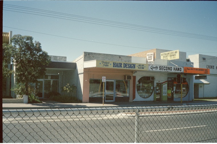 Image courtesy SLWA
2014,  Image courtesy element
Stop 17. Samara Aesthetics 918 Beaufort St
1951 Kings Mobile Vegetable and Fruit Supply
Image courtesy SLWA
1st building on this site in 1961
Stop 18. Lisa Baker Member for Maylands 946 Beaufort St
1985 View from Crawford Road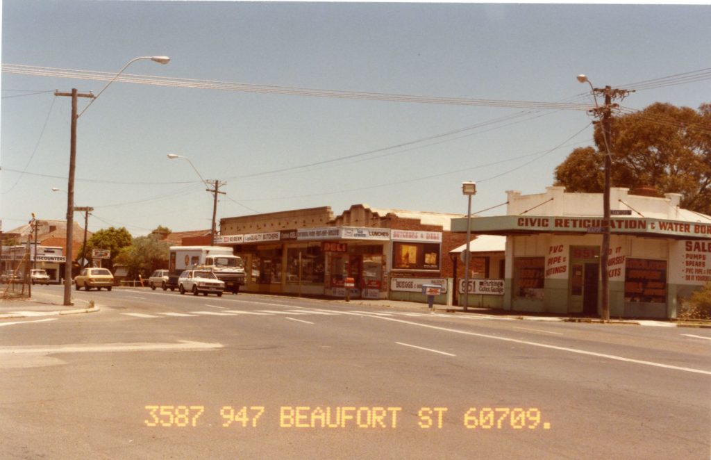
1985 View towards Perth, near Crawford Road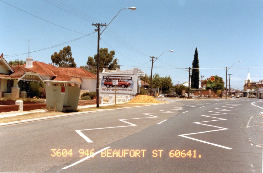
1985 View towards Perth, near Waterford St.
Images courtesy CoS History Collection
The kink in Beaufort St is very visible. It was lessened in 2003 with the demolition of Stan’s Rug Shop and PR Allen.
Stop 19. Chef and Co. 1000 Beaufort St
1951 Bedford Drapery 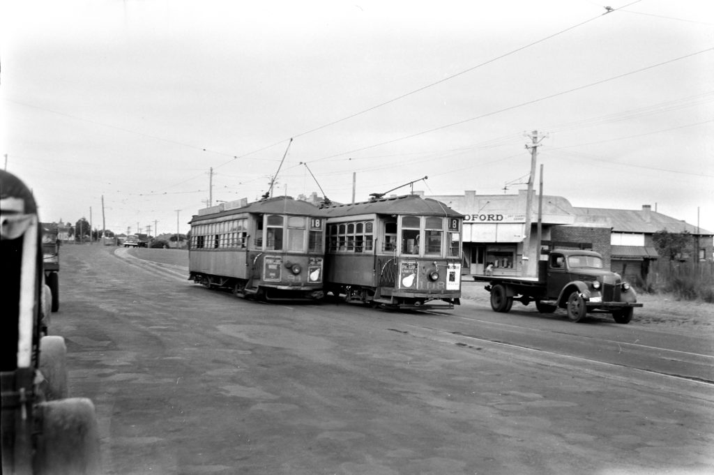 Image – Noel Reed courtesy Track of the Swan
Cars 91 & 108 pass at the end of the double track at Salisbury St not far from the Inglewood Terminus at Grand Prom.
This building has been a children’s outfitter (& library), Suzette’s Fashions (from Italy), a florist, Haberdashery 1000, since 2000, various restaurants.
Stop 20. Kustom Klaw 1004 Beaufort St
1958 Tylers Store & Tram
Image Tony Culpeffer-Cooke Courtesy Tracks by the Swan
1970 Tylers Store interior. Mrs Tyler and son

Image courtesy SLWA
3 shops and a residence were built in 1936 for £2000. Tyler’s Store, also called Tyler’s Corner operated in this set of shops until 1979, along with a hairdresser, newsagent/post office branch & chemist.
Trams were extended into Inglewood on 17 August 1923. A single line from 2nd Ave to 7th Ave. Extended to Dundas Road 25th August 1929, Salisbury St 19 February 1933, Grand Prom 8 March 1943. The final tram, no. 66 was 19 July 1958.
Stop 21. Inglewood Pre-Primary Hamer Pde,
1958 Inglewood Kindergarten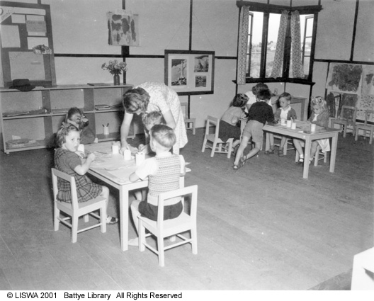

Images courtesy SLWA
1958 Mt Lawley Tennis Pavilion transported to its current site.
 Image courtesy CoS History Collection
Inglewood Triangle (across the road from Pre-Primary) is a near city example of a Banksia Woodland community. It provides a window into the past showing natural bushland that once covered the area. There are no records to show how it escaped development in 1930s.
References: Original Crown Grants (1833-1844) and Localities within The City of Stirling. Gordon R Shearwood & Olga B Shearwood 1988
Stirling City. Leonard A Easton 1971
Diversity’s Challenge, A History of the City of Stirling. WS Cooper & G McDonald 1999
History in Their Own Words: Tales from the Oral History Collection Transcripts
State Records Office WA, State Library WA, Mt Flora Regional Museum, Mount Lawley Society, Friends of Inglewood Triangle, Landgate Map Viewer Plus, RetroMaps. Post Office Directories
Dodgy Perth FB, Perth Reflects FB, Perth Art Deco.net.au, local residents.